DSP Application Profile
- Created:
2026-02-25
- Published:
2026-05-07
- Modified:
2026-08-11
- Version:
- 0.9.1
Introduction
Purpose and Scope
This application profile defines the standards, vocabularies, and patterns required to publish and integrate environmental data within the DEFRA Data Services Platform (DSP) federated data architecture. It applies to data published on environment.data.gov.uk by DEFRA and its arm's-length bodies—including the Environment Agency—for third parties seeking to integrate with that data ecosystem.
The profile is not a replacement for domain-specific data standards. It is a composability layer: a set of conventions that allow independently managed systems to share meaning without requiring schema convergence or custom integration code. Adopting this profile is the mechanism by which a system becomes part of DEFRA's federated data landscape.
The Problem This Profile Addresses
DEFRA's environmental data estate spans dozens of applications, APIs, and portals—each developed independently across several years, each using its own terminology, and each requiring bespoke effort to connect to any other. The cost of integration grows exponentially with the number of systems: connecting the 28th system has historically required understanding and mapping to each of the 27 that came before it.
This fragmentation has direct consequences for data users. Finding relevant data requires simultaneous domain expertise and technical knowledge of individual systems. Cross-domain analysis—linking water quality measurements to biodiversity observations and land use classifications, for example—demands manual effort that is rarely proportionate to its value. Data held in end-of-life systems risks becoming inaccessible when those systems are retired.
This application profile addresses these problems by establishing a shared semantic layer built on W3C Linked Data standards. Systems that adopt the profile express how their data relates to shared vocabularies once; the federated architecture handles the connections automatically, at linear rather than exponential cost.
FAIR Principles and the Linked Data Ecosystem
This profile is grounded in the FAIR data principles —Findable, Accessible, Interoperable, and Reusable—which provide the framework for making environmental data a long-term asset rather than a short-term artefact.
W3C's Linked Data ecosystem is the primary technical mechanism by which FAIR principles are operationalised at scale:
FAIR Principle |
What It Requires |
How Linked Data Enables It |
|---|---|---|
Findable |
Persistent identifiers; rich, indexed metadata |
Every resource is assigned a dereferenceable URI; datasets are described using DCAT and published to federated catalogues automatically |
Accessible |
Retrievable via open, standardised protocols |
HTTP content negotiation serves the same resource as web pages, CSV, GeoJSON, or RDF—no specialist tooling required |
Interoperable |
Data uses shared vocabularies and formal knowledge representations |
W3C standards (RDF, SKOS, SOSA/SSN, OWL) provide machine-readable shared meaning; relationships between domain-specific terms and cross-domain concepts are declared explicitly |
Reusable |
Rich provenance, licensing, and domain-relevant context |
Versioned vocabularies, dataset-level provenance metadata, and standards-compliant licensing declarations ensure data can be understood and reused beyond its originating system |
A key design principle of this profile is semantics sooner: establishing relationships between datasets early, and refining definitions over time, is explicitly preferred over waiting for perfect consensus before publishing. Relationships expressed under this profile survive vocabulary evolution; tightly coupled custom integrations do not.
Six Data Types
Environmental data within the DEFRA ecosystem is diverse in structure, granularity, and purpose. This profile addresses six broad categories, each with its own standards alignment and integration conventions:
Catalogue — Discovery metadata describing datasets, services, and their relationships. Enables users to find data across the ecosystem without knowing which system holds it. Aligned to DCAT.
Concept — Controlled vocabularies, code lists, and taxonomies. Provides the shared meaning that allows different domains to recognise equivalent terms—“Sampling Point" in water quality and “Observation Site" in ecology refer to the same concept. Aligned to SKOS.
Geography — Named locations with spatial extents: sampling points, catchment boundaries, administrative areas, and designated sites. A location defined once can serve planning, biodiversity monitoring, and water quality reporting simultaneously. Aligned to GeoSPARQL with GeoJSON and WKT representations.
Custom — Domain-specific entities with structured attributes: organisations, permits, consents, assets, and similar objects whose richness cannot be reduced to a flat table. Aligned to domain ontologies with OWL-based class definitions.
Observations — Measurement data: the readings produced by sensors, surveys, and sampling programmes. The most voluminous data type in environmental monitoring, and the one most critical to cross-domain analysis. Aligned to W3C SOSA/SSN.
Cubes — Pre-aggregated statistical summaries: annual averages, spatial aggregations, indicator time series. Enables fast access to derived data without re-processing raw observations for every query.
Each section of this profile specifies the mandatory and recommended properties, vocabulary bindings, and serialisation formats for its respective data type.
Integration with DEFRA and Environment Agency Data
Systems integrating with the DEFRA data ecosystem under this profile are not required to replace their internal data models. The shared semantic layer operates above existing systems: adopting systems declare how their entities, terms, and measurements relate to the shared vocabularies defined in this profile, enabling consistent discovery and access across domain boundaries.
Integration follows a progressive model:
Minimum compliance — Publish dataset-level catalogue metadata (DCAT) with persistent URIs and a machine-readable licence. This makes data findable and accessible with minimal implementation effort.
Vocabulary alignment — Map domain-specific code lists and classifications to SKOS concept schemes. This enables consistent term resolution across domains.
Observation alignment — Express measurement data using SOSA/SSN patterns. This enables water quality, ecology, hydrology, and other observational datasets to share a common structure.
Full alignment — Expose data through standards-compliant RESTful API endpoints following the conventions in this profile. This enables consumers to perform their own cross-domain queries by combining responses from multiple endpoints using shared identifiers and vocabularies.
Each level of compliance delivers independent value; full alignment is not a prerequisite for participation. The architecture is designed so that a system at minimum compliance can be progressively enhanced without breaking existing integrations or requiring external systems to change.
Cross-domain data integration is achieved by consumers using DEFRA's RESTful API endpoints directly. Because all aligned datasets share persistent URIs and common vocabularies, data retrieved from multiple endpoints can be combined without custom mapping—the shared identifiers do the joining. This approach keeps the architecture composable and practical: consumers use familiar HTTP-based tools, and integration complexity remains with the standards rather than with bespoke infrastructure.
This profile is maintained by the DEFRA Data Services Platform programme. Versioning follows semantic versioning conventions; changes to mandatory properties constitute a major version increment. Implementers are encouraged to engage with the programme team early in development to ensure alignment.
Conventions
Linked data examples in this document may be provided in Turtle or JSON-LD formats as appropriate.
Terms
In this document, we use standard linked data & RDF terms, so it may be helpful to read through the RDF Primer.
Here is a quick summary of terms for reference:
Term |
Definition |
|---|---|
Resource |
Anything that can be described |
Uniform Resource Identifier (URI) |
A character string which identifies a resource. Limited to ASCII character space (similar to a URL but not necessarily accessible via HTTP requests). |
Internationalized Resource Identifier (IRI) |
A character string which identifies a resource. Like a URL or URI, but more general, accepting a greater range of characters. |
Literal |
A basic value such as a string, integer, real number. Strings may be tagged with a language. |
Triple (Subject, Predicate, Object) |
A statement about the Subject resource (URI), using a Predicate URI, about an Object, which may be an URI or a Literal. If the Object is also an URI, the statement establishes a relationship between the Subject & Object. In other terms, each statement can generally be described to assign an attribute (Predicate) to the Subject object, with the value being the Object. |
Namespace |
An alias for an URI prefix, used for convenience to keep predicates short and to improve readability |
Domain |
Permitted types of subjects for a given predicate |
Range |
Permitted data types of objects for a given predicate, which must be respected. The term “includes" is used to make the range less restrictive, downgrading “must" into “should". When the phrase a <data type> is used, this indicates the object must be the value of an URI of a resource of the given data type. |
Cardinality |
The number of times a predicate may be used per given subject.
|
Coining |
The act of assigning an URI (identifier) to a resource. |
Blank node |
A resource without globally unique URI. In Turtle syntax, blank nodes may be labelled for reuse, or nested, see RDF 1.1 Turtle. |
Slugification |
The process of making a string a valid component of a URL. For the purpose of this document, this involves:
|
Namespaces
Namespace |
Namespace URI |
Specification |
|---|---|---|
dcat: |
||
dcterms: |
||
ddiam: |
http://vocabularies.cessda.eu/urn/urn:ddi:int.ddi.cv:AggregationMethod:1.1.2/ |
|
defra-core: |
||
foaf: |
||
geo: |
||
iop: |
||
owl: |
||
prov: |
||
qb: |
||
qudt: |
||
rdf: |
||
rdfs: |
||
schema: |
||
skos: |
||
sosa: |
||
unit: |
||
xsd: |
W3C XML Schema Definition Language (XSD) 1.1 Part 2: Datatypes |
Data Types
For the various data types, we provide guidelines to be followed for our own purposes.
We provide the predicates that must, should, and may be used for each given subject of the data type, as well as the ranges of their possible objects, and their cardinality, i.e. how many times they may be specified for the given subject. These specifications are intended to produce high quality, meaningful, and comprehensible linked data. See Terms for a definition and explanation of Range and Cardinality for this document.
In the case where the valid predicates, ranges, or cardinalities differ from their respective original ontologies, the rules in this application profile should supersede them.
Catalogue
dcat:Dataset
dcat:Dataset represents a collection of data, published or curated by a single agent or identifiable community. The notion of dataset in DCAT is broad and inclusive, with the intention of accommodating resource types arising from all communities. Data comes in many forms including numbers, text, pixels, imagery, sound and other multi-media, and potentially other types, any of which might be collected into a dataset.
– DCAT spec
We use Datasets for each conceptual group of data.
Each dataset should be part of a dcat:Catalog, which should be specified using dcat:dataset on the dcat:Catalog.
Temporal datasets are ones which only relate to, or are only valid for, a specific period of time. For temporal datasets, dcterms:temporal must be used to indicate that period of time.
A dcat:Dataset may also be a skos:ConceptScheme.
When we import versioned datasets, if each version of dataset also contains data from previous versions, we should import and keep only the latest version.
Otherwise, we should make multiple versions of a dataset available. The related datasets should be linked together using dcat:previousVersion and dcat:nextVersion. The latest version should be linked to using dcat:hasCurrentVersion in the dcat:Catalog which contains the versioned datasets.
Predicate |
Range |
Requirement |
Cardinality |
Notes |
|---|---|---|---|---|
dcterms:title |
Literal xsd:string |
Must |
1..* |
May be repeated for multiple languages |
dcterms:description |
Literal xsd:string |
Must |
1..* |
May be repeated for multiple languages |
dcterms:publisher |
Includes URI |
Must |
1 |
Defaults to dcat:publisher of the dcat:Catalog. May be URL of the publisher’s website, e.g. https://environment.data.gov.uk/. May default as appropriate |
dcterms:license |
Includes URI |
Must |
1..* |
May be the URL of the license text, e.g. https://www.nationalarchives.gov.uk/doc/open-government-licence/version/3/ |
dcterms:created |
Literal xsd:dateTime |
Must |
1 |
Defaults to now() |
dcterms:temporal |
a dcterms:PeriodOfTime |
Must, if dataset is temporal |
0..1 |
If the dataset is only relates to a specific period of time. E.g. |
dcterms:accrualPeriodicity |
a dcterms:Frequency |
Should |
0..1 |
If versions of the dataset is published regularly, especially if the dataset is temporal, the frequency at which it is published. E.g. yearly. |
dcterms:creator |
Includes URI |
Should |
0..1 |
If publisher is not the creator |
dcterms:issued |
Literal xsd:date |
Should |
0..1 |
If specified by the publisher |
foaf:page |
Includes URI |
Should |
0..* |
If available, a web-resolvable URL to human-readable documentation of the Dataset. |
dcat:temporalResolution |
Literal xsd:duration |
Should |
0..1 |
If the dataset is computed, or is a cube, and has a time period, this is the minimum time period within the cube. |
dcat:contactPoint |
a vcard:Kind |
Should |
0..* |
Contact point for support about the Dataset/DataService |
dcat:inCatalog |
a dcat:Catalog |
Should |
0..* |
Parent catalog(s) this dataset belongs to. We sometimes use this predicate where the object is of type dcat:Dataset but we accept the inference that the dcat:Dataset can be inferred to also be a dcat:Catalog (even though it isn't explicitly typed as one) |
dcat:theme |
a skos:Concept |
Should |
0..* |
Themes, topics this dataservice covers. E.g. environment, rivers, water quality. |
dcat:themeTaxonomy |
URI |
May |
0..* |
The SKOS:ConceptScheme/s used to describe data within the dcat:Dataset. |
dcat:downloadURL |
URI |
May |
0..* |
If provided by the publisher. Provides a direct download link for the source of our data. Should be a web-resolvable URL. |
dcterms:source |
a rdfs:Resource with rdfs:label |
May |
0..* |
If a URL cannot be provided in dcat:accessURL, a human-readable description of the source. |
dcterms:language |
Literal ISO 639-1 two-letter or ISO 639-2 three-letter code xsd:string |
May |
0..* |
If specified, and not just English. E.g. dcterms:language "en", “cy" ; for both English and Welsh (Cymraeg). |
skos:editorialNote |
Literal xsd:string |
May |
0..* |
Additional meta information about the Dataset. |
dcat:DataService
A collection of operations that provides access to one or more datasets or data processing functions.
– DCAT spec
A dcat:DataService may also be a dcat:Catalog. The distinction between a plain catalogue and a data service is fuzzy. A general rule of thumb is, if the catalog provides access to dcat:Distributions, a catalogue is probably also data service. If properly representing the dataset would require using dcterms:temporal, dcterms:spatial, or dcat:inSeries, it should be represented with a dcat:Dataset.
Predicate |
Range |
Requirement |
Cardinality |
Notes |
|---|---|---|---|---|
dcat:endpointURL |
URI |
Must |
1 |
Web-resolvable URI to the endpoint which serves datasets. |
dcat:servesDataset |
URI |
Should |
0..* |
dcat:Datasets provided by this service. |
dcat:endpointDescription |
Includes URI |
Should |
0..1 |
If available, a reference to the documentation of the Dataset. Preferably machine-readable, or for programmatic access such as a Swagger documentation page. If nothing machine-readable is available, should duplicate foaf:page. May be a web-resolvable URL. |
dcat:theme |
a skos:Concept |
Should |
0..* |
Themes, topics this dataservice covers. E.g. environment, rivers, water quality. |
dcterms:type |
Includes a skos:Concept |
May |
0..* |
Types of operations supported by the service. E.g. view, update, download, |
dcat:Catalog
dcat:Catalog represents a catalog, which is a dataset in which each individual item is a metadata record describing some resource; the scope of dcat:Catalog is collections of metadata about datasets, data services, or other resource types.
– DCAT spec
Each dataset should be part of a dcat:Catalog, which should be specified using dcat:inCatalog on the dcat:Dataset.
A Catalog is a specialisation of dcat:Dataset, adding only the predicate dcat:dataset to specify its members.
Predicate |
Range |
Requirement |
Cardinality |
Notes |
|---|---|---|---|---|
dcterms:title |
Literal xsd:string |
Must |
1..* |
|
dcterms:description |
Literal xsd:string |
Must |
1..* |
|
dcat:contactPoint |
a vcard:Kind |
Should |
0..* |
Contact point for support about the catalog specifically, not the datasets or entries contained within. May be set to an appropriate default for the service. |
dcterms:license |
Includes URI |
Should |
0..* |
License for the catalog specifically, not the datasets or entries contained within. May be set to an appropriate default for the service. |
dcterms:publisher |
Includes URI |
Should |
0..* |
Publisher of the catalog specifically, not the datasets or entries contained within. May be set to an appropriate default for the service. |
dcat:Distribution
A specific representation of a dataset. A dataset might be available in multiple serializations that may differ in various ways, including natural language, media-type or format, schematic organization, temporal and spatial resolution, level of detail or profiles (which might specify any or all of the above).
– DCAT spec
Predicate |
Range |
Requirement |
Cardinality |
Notes |
|---|---|---|---|---|
dcterms:title |
Literal xsd:string |
Must |
1..* |
|
dcat:downloadURL |
URI |
Must |
1..1 |
|
dcat:accessURL |
URI |
Should |
0..1 |
|
dcat:accessService |
a dcat:DataService |
Should |
0..1 |
|
dcat:description |
Literal xsd:string |
Should |
0..* |
|
dcterms:license |
URI |
Should |
0..1 |
|
dcat:temporalResolution |
Literal xsd:duration |
Should |
0..1 |
If the dataset is computed, or is a cube, and has a time period, this is the minimum time period within the cube. |
dcterms:mediaType |
a dcterms:MediaType |
May |
1 |
|
dcterms:format |
a dcterms:MediaTypeOrExtent |
May |
0..1 |
|
dcterms:compressFormat |
a dcterms:MediaType |
May |
0..1 |
|
dcat:packagingFormat |
a dcterms:MediaType |
May |
0..1 |
|
dcterms:modified |
Literal, including xsd:dateTime |
May |
0..1 |
|
dcat:spatialResolutionInMeters |
Literal, including xsd:decimal |
May |
0..1 |
|
dcterms:issued |
Literal, including xsd:dateTime |
May |
0..1 |
|
dcterms:accessRights |
a dcterms:RightsStatement |
May |
0..1 |
Catalogue JSON-LD mapping
RDF Attribute |
JSON-LD key |
JSON-LD value |
Notes |
|---|---|---|---|
dcat:accessURL |
accessURL |
Literal value as string |
|
dcterms:created |
issuedDate |
Literal value as string |
|
dcterms:creator |
creator |
Literal value as string |
|
dcterms:description |
description |
Literal value as string |
|
dcat:themeTaxonomy |
themeTaxonomy |
URI as string |
|
dcat:downloadURL |
downloadURL |
Literal value as string |
|
dcat:endpointDescription |
docs |
Literal value as string |
|
dcterms:license |
license |
URI as string |
For the Open Government License we use the URL which is https://www.nationalarchives.gov.uk/doc/open-government-licence/version/3/ and we ensure our JSON-LD context treats this as an ID. |
dcterms:publisher |
publisher |
Literal value as string |
|
dcat:temporalResolution |
temporalResolution |
Literal value as string |
|
dcat:contactPoint |
contactPoint |
vcard:Kind as JSON-LD |
For example |
dcterms:title |
title |
Literal value as string |
|
dcterms:issued |
issued |
Literal value as string |
|
dcterms:language |
language |
Literal value as string |
|
dcterms:modified |
lastModified |
Literal value as string |
|
dcterms:source |
source |
Literal value as string |
|
dcterms:temporal |
timeRange |
Object with start and end as string |
|
dcterms:conformsTo |
|||
dcat:theme |
theme |
skos:prefLabel of skos:Concept |
|
foaf:page |
humanDocs |
Literal value as string |
|
foaf:primaryTopic |
primaryTopic |
URI as string |
|
skos:editorialNote |
editorialNote |
Literal value as string |
|
hasDatasets |
URI |
Applicable to dcat:Catalog |
Our modelling approach using DCAT3
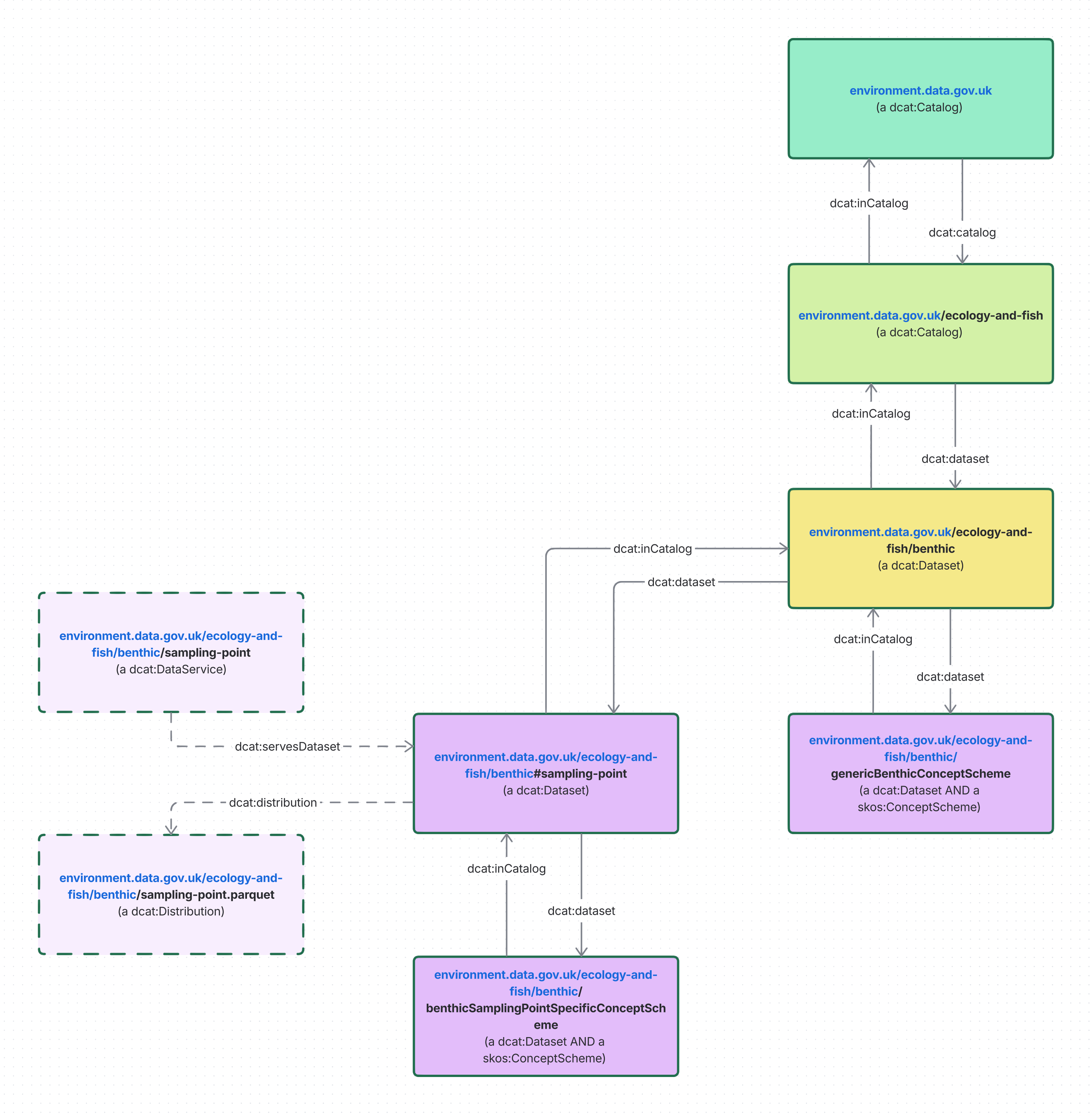
The diagram above visualises how we model dcat:Catalogs and dcat:Datasets. At the top level is environment.data.gov.uk which is a dcat:Catalog, it contains other dcat:Catalogs such as the ecology-and-fish or the data-requirements catalog. Each of these sub-catalogs generally contain dcat:Datasets, but they can also contain other dcat:Catalogs. In the diagram above the only distinct dcat:Catalog is the environment.data.gov.uk catalog, and the only distinct dcat:Datasets are the skos:ConceptSchemes. While we explicitly type each dcat:Datasets only as a dcat:Datasets the use of certain predicates such as dcat:inCatalog or dcat:themeTaxonomy results in the dcat:Dataset being inferred (by an RDF reasoner) to also be a dcat:Catalog, we have made this choice as they should be seen as a dcat:Dataset resource first and foremost.
Concept
skos:ConceptScheme
A SKOS concept scheme can be viewed as an aggregation of one or more SKOS concepts
– SKOS spec
A skos:ConceptScheme must also be a dcat:Dataset.
A skos:ConceptScheme must also contain at least one skos:Concept using the skos:topConceptOf predicate.
Predicate |
Range |
Requirement |
Cardinality |
Notes |
|---|---|---|---|---|
skos:prefLabel |
Literal xsd:string |
Must |
1..* |
Human-readable name |
skos:notation |
Literal xsd:string |
Must |
1 |
Should be provided by the data source |
skos:definition |
Literal xsd:string |
Should |
0..* |
Description or formal definition of the concept scheme |
skos:altLabel |
Literal xsd:string |
May |
0..* |
Additional human-readable names |
skos:note |
Literal xsd:string |
May |
0..* |
Additional information about the concept scheme |
skos:Concept
A SKOS concept can be viewed as an idea or notion; a unit of thought. However, what constitutes a unit of thought is subjective, and this definition is meant to be suggestive, rather than restrictive.
– SKOS spec
A skos:Concept must be linked to at least one skos:ConceptScheme using skos:inScheme, and may be linked to any number of those same concept schemes with skos:topConceptOf.
A skos:Concept should use skos:broader and skos:narrower to indicate hierarchy.
Predicate |
Range |
Requirement |
Cardinality |
Notes |
|---|---|---|---|---|
skos:inScheme |
a skos:ConceptScheme |
Must |
1 |
Scheme(s) this concept belongs to |
skos:prefLabel |
Literal xsd:string |
Must |
1..* |
Human-readable name |
skos:notation |
Literal xsd:string |
Must |
1 |
Should be provided by the data source |
skos:definition |
Literal xsd:string |
Should |
0..* |
Description or formal definition of the concept |
skos:broader
skos:narrower
|
a skos:Concept |
Should |
0..* |
Hierarchical relationships |
skos:topConceptOf |
a skos:ConceptScheme |
May |
0..* |
Inferred, should be present if the skos:Concept has no skos:broader relationship. |
skos:altLabel |
Literal xsd:string |
May |
0..* |
Additional human-readable names |
skos:note |
Literal xsd:string |
May |
0..* |
Additional information about the concept |
skos:closeMatch
skos:exactMatch
skos:broadMatch
skos:narrowMatch
skos:relatedMatch
|
a skos:Concept |
May |
0..* |
To indicate related concepts |
skos:Collection
SKOS concept collections are labeled and/or ordered groups of SKOS concepts.
Collections are useful where a group of concepts shares something in common, and it is convenient to group them under a common label, or where some concepts can be placed in a meaningful order
– SKOS spec
When appropriate, skos:Concepts are grouped together into skos:Collections with skos:member. This can be nested, such that a skos:Collection may contain other skos:Collections.
A collection can be treated as a dataset, therefore it may be a dcat:Dataset.
Collections do not support hierarchy. If relationships are required between skos:Concepts across multiple skos:ConceptSchemes, those concepts should be duplicated into another scheme, and skos:exactMatch used to indicate they are equivalent, then skos:narrower and skos:broader indicate as usual the hierarchy.
Predicate |
Range |
Requirement |
Cardinality |
Notes |
|---|---|---|---|---|
skos:member |
a skos:Collection or a skos:Concept |
Should |
0..* |
|
rdfs:label |
Literal xsd:string |
May |
0..* |
Concept JSON-LD mapping
RDF Attribute |
JSON-LD key |
JSON-LD value |
Notes |
|---|---|---|---|
skos:prefLabel |
prefLabel |
Literal value as string |
|
skos:altLabel |
altLabel |
Literal value as string |
|
skos:definition |
description |
Literal value as string |
|
skos:note |
note |
Literal value as string |
|
skos:broader |
broader |
JSON-LD encoded skos:Concept |
|
skos:narrower |
narrower |
JSON-LD encoded skos:Concept |
|
hasTopConcepts |
Includes endpoint URI, or URI of skos:Concept |
Applicable to skos:ConceptScheme. Inferred from children of the skos:ConceptScheme who are skos:topConceptOf – itself inferred by lack of skos:broader. May be an endpoint which performs a query, or an automatically populated array |
|
hasMembers |
Includes endpoint URI, or URI of resource |
Applicable to skos:Collection. |
Concepts worked example
As of writing, the UK's administrative geographies are hierarchically organised according to the following diagram:
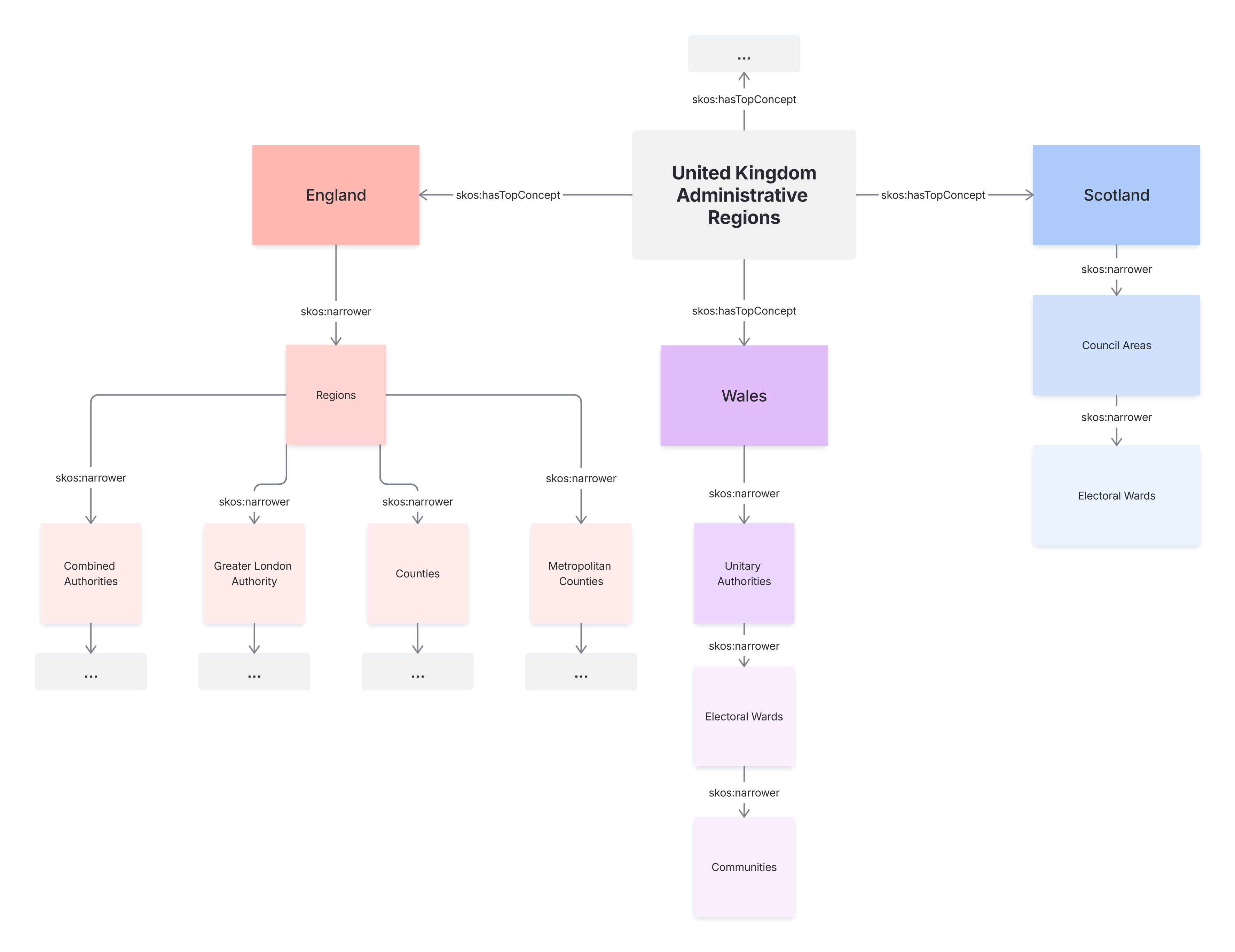
We would represent this with the following skos:ConceptScheme:
The UK is broken down into Countries, each being a skos:topConceptOf of the UK, one of which being Wales
Wales is broken down into many skos:narrower Unitary Authorities
Each Unitary Authority is broken down into many skos:narrower Electoral Wards
Each Electoral Ward is broken down into many skos:narrower Communities
A subgraph of this relationship could be represented by the following RDF, using Government Statistical Service (GSS) codes for notation:
@prefix ex: <http://www.example.org/> .
@prefix skos: <http://www.w3.org/2004/02/skos/core#> .

ex:UnitedKingdomAdministrativeRegions a skos:ConceptScheme ;
    skos:prefLabel "United Kingdom Administrative Regions"@en .

ex:W92000004 a skos:Concept ;  # Country
    skos:inScheme ex:UnitedKingdomAdministrativeRegions ;
    skos:notation "W92000004" ;
    skos:prefLabel "Cymru"@cy, "Wales"@en ;
    skos:note "Established in 1057"@en ;
    skos:topConceptOf ex:UnitedKingdomAdministrativeRegions .

ex:W06000015 a skos:Concept ;  # Unitary Authority
    skos:inScheme ex:UnitedKingdomAdministrativeRegions ;
    skos:broader ex:W92000004 ;
    skos:notation "W06000015" ;
    skos:prefLabel "Cyngor Caerdydd"@cy, "Cardiff Council"@en .

ex:W05001274 a skos:Concept ;  # Electoral Ward
    skos:inScheme ex:UnitedKingdomAdministrativeRegions ;
    skos:broader ex:W06000015 ;
    skos:notation "W05001274" ;
    skos:prefLabel "Cathays"@cy, "Cathays"@en .

ex:W06000011 a skos:Concept ;  # Unitary Authority
    skos:inScheme ex:UnitedKingdomAdministrativeRegions ;
    skos:broader ex:W92000004 ;
    skos:notation "W06000011" ;
    skos:prefLabel "Cyngor Abertawe"@cy, "Swansea Council"@en .

ex:W39000434 a skos:Concept ;  # Electoral Ward and Community
    skos:inScheme ex:UnitedKingdomAdministrativeRegions ;
    skos:broader ex:W06000011 ;
    skos:notation "W39000434" ;
    skos:prefLabel "Castell"@cy, "Castle"@en .
Each region, regardless of their position in the hierarchy, is skos:inScheme the skos:ConceptScheme containing “administrative regions". Their hierarchical relationships are in this case represented by the lower administrative regions using skos:broader to refer to the higher region they belong. Equally valid, the higher administrative regions could use skos:narrower to refer to all the lower regions contained within them.
Geography
geo:FeatureCollection
A collection of individual Features
– OGC GeoSPARQL spec
An instance of geo:FeatureCollection should have at least one outgoing rdfs:member relation
– OGC GeoSPARQL spec
We use geo:FeatureCollections to group related geographic features, such as water quality sampling points, or administrative regions.
Each geo:FeatureCollection must also be a dcat:Dataset, and follow all requirements of a dcat:Dataset.
When a geo:FeatureCollection represents commonly understood geographies, e.g. cities or countries, geo:FeatureCollection should also be a skos:ConceptScheme, in which case it should follow all requirements of a skos:ConceptScheme.
Predicate |
Range |
Requirement |
Cardinality |
Notes |
|---|---|---|---|---|
rdfs:member |
a geo:Feature |
Should |
0..* |
geo:Feature
Feature represents a uniquely identifiable phenomenon, for example a river or an apple. While such phenomena (and therefore the Features used to represent them) are bounded, their boundaries may be crisp (e.g., the declared boundaries of a state), vague (e.g., the delineation of a valley versus its neighboring mountains), and change with time (e.g., a storm front). While discrete in nature, Features may be created from continuous observations, such as an isochrone that determines the region that can be reached by ambulance within 5 minutes
– OGC GeoSPARQL spec
We use geo:Features to represent individual geographic features or regions, such as a city, or an administrative region.
When a geo:Feature represents a commonly understood geography, e.g. a city or country, it should also be a skos:Concept, in which case it should follow all requirements of a skos:Concept.
Where a conceptual geography has inexact or unavailable boundaries, it is typed as a skos:Concept rather than a geo:Feature. Its spatial nature can be inferred from context: where other geo:Feature instances are declared geo:sfWithin it, users may treat it as an implicit geo:Feature.
Predicate |
Range |
Requirement |
Cardinality |
Notes |
|---|---|---|---|---|
geo:hasGeometry |
a geo:Geometry |
Should |
1 |
|
geo:sfWithin
geo:sfContains
|
a geo:Feature |
Should |
1..* |
Any boundaries which a feature exists within, or features which are contained within a boundary, should be linked via geo:sfWithin or geo:sfContains respectively. |
geo:Geometry
A coherent set of direct positions in space. The positions are held within a Spatial Reference System (SRS).
– OGC GeoSPARQL spec
We use geometries to store the precise bounding area of a geography, in well-known text format using the geo:asWKT predicate. Usually, this geometry should be encoded as a MultiPolygon, to support geographies composed of multiple distinct shapes. For example, islands
For convenience, we should provide the bounding box and centroid of a geography with geo:hasBoundingBox and geo:hasCentroid respectively.
Geometries should be provided with the following shapes and anchors if coined:
Geometry |
Shape type |
Anchor (if coined) |
Notes |
|---|---|---|---|
Full geometry |
MultiPolygon or Polygon |
#geometry |
If the geometry is non-contiguous, a MultiPolygon should be used. |
Bounding box |
Polygon |
#bbox |
|
Centroid |
Point |
#centroid |
Predicate |
Range |
Requirement |
Cardinality |
Notes |
|---|---|---|---|---|
geo:asWKT |
Literal geo:wktLiteral |
Must |
1 |
Must explicitly encode the spatial reference system, which should be EPSG:4326, unless a different system is requested: |
geo:coordinateDimension |
Literal xsd:decimal |
Must |
1 |
Number of axes in the geometry |
geo:hasBoundingBox |
a geo:Geometry |
Should |
0..1 |
Should be provided if the geometry is at least 2-dimensional, unless this geometry represents another’s bounding box. Should be a Polygon |
geo:hasCentroid |
a geo:Geometry |
Should |
0..1 |
Should be provided if the geometry is at least 2-dimensional. Should be provided as a WKT Point. |
Geography JSON-LD mapping
RDF Attribute |
JSON-LD key |
JSON-LD value |
Notes |
|---|---|---|---|
geo:hasGeometry |
geometry |
geo:Geometry object serialised as JSON-LD |
|
geo:asWKT |
asWKT |
Literal value as string |
|
geo:hasBoundingBox |
bbox |
geo:Geometry object serialised as JSON-LD |
|
geo:hasCentroid |
centroid |
geo:Geometry object serialised as JSON-LD |
|
geo:coordinateDimension |
coordinateDimension |
Literal value as integer |
|
geo:sfWithin |
Name of the classification of Feature which contains this geo:Feature, in camelCase |
geo:Feature object serialised as JSON-LD |
Only keys … of related geo:Feature |
GeoJSON mapping
When transferring geographies via our APIs, we may support using GeoJSON (MIME application/geo+json) to encode them, if it is requested via the Accept header.
RDF resources and attributes and should be provided in the properties of the GeoJSON object, according to the following mapping:
RDF Attribute |
GeoJSON key |
GeoJSON value |
Notes |
|---|---|---|---|
isDistributionOf |
Resource URL |
The URL of the Resource from which this GeoJSON object was generated |
|
skos:notation |
notation |
Literal value as string |
|
skos:prefLabel |
name |
Literal value as string |
|
skos:altLabel |
altName |
Literal value as string |
|
skos:definition |
description |
Literal value as string |
|
skos:note |
note |
Literal value as string |
Each skos:Concept assigned to the geo:Feature should also be present in the properties of the GeoJSON object, with the camelCase name of its skos:ConceptScheme used as the key, and the skos:Concept's URI as the value. See the worked example below.
The properties should generally not contain complex data types such as objects. Arrays may be used when appropriate.
Geography worked example
The Ecology and Fish (Benthic dataset) sampling point endpoint for the sampling point 135967-v1 returns the following JSON-LD response, which has been cut down for simplicity:
{
  "id": "http://environment.data.gov.uk/ecology-and-fish/benthic/sampling-point/135967-v1",
  "@type": "sosa:FeatureOfInterest",
  "geometry": {
    "@id": "http://environment.data.gov.uk/ecology-and-fish/benthic/sampling-point/135967-v1#Geometry",
    "@type": "geo:Geometry",
    "asWKT": "<http://www.opengis.net/def/crs/EPSG/0/27700> POINT(430031 606343)"
  },
  "seaArea": "http://environment.data.gov.uk/ecology-and-fish/benthic/sea-areas/Concept/northumberland",
  "notation": "135967-v1",
  "agencyArea": "http://environment.data.gov.uk/ecology-and-fish/benthic/agency-areas/Concept/national-marine",
  "reportingArea": "http://environment.data.gov.uk/ecology-and-fish/benthic/reporting-areas/Concept/north-east",
  "waterbodyType": "http://environment.data.gov.uk/ecology-and-fish/benthic/waterbody-types/Concept/wbcw",
  "wfdWaterbodyId": "http://environment.data.gov.uk/ecology-and-fish/benthic/wfd-waterbodies/Concept/GB650301500001"
}
The same subject is transformed into the following GeoJSON when requested:
{
  "type": "Feature",
  "geometry": {
    "coordinates": [
      -1.527978174,
      55.350201484
    ],
    "type": "Point"
  },
  "properties": {
    "notation": "135967-v1",
    "@type": "sosa:FeatureOfInterest",
    "seaArea": "http://environment.data.gov.uk/ecology-and-fish/benthic/sea-areas/Concept/northumberland",
    "agencyArea": "http://environment.data.gov.uk/ecology-and-fish/benthic/agency-areas/Concept/national-marine",
    "reportingArea": "http://environment.data.gov.uk/ecology-and-fish/benthic/reporting-areas/Concept/north-east",
    "waterbodyType": "http://environment.data.gov.uk/ecology-and-fish/benthic/waterbody-types/Concept/wbcw",
    "wfdWaterbodyId": "http://environment.data.gov.uk/ecology-and-fish/benthic/wfd-waterbodies/Concept/GB650301500001"
  }
}
Custom
The data provided by our services uses terms from established vocabularies in order to improve interoperability. However some vocabulary needed to describe our data are not represented in existing vocabulary and in these cases we define our own classes and predicates.
RDF Schema (RDFS) and OWL vocabulary is used for defining new classes and predicates.
Classes
A new class is of type owl:Class and the following predicates are used to describe it:
Predicate |
Range |
Requirement |
Cardinality |
Notes |
|---|---|---|---|---|
rdfs:label |
Literal xsd:string |
Must |
1 |
The human-readable label of the class |
rdfs:comment |
Literal xsd:string |
Must |
1 |
A description of the class which provides more context about when the class should be used |
rdfs:subClassOf |
a rdfs:Class or a owl:Class |
May |
0..* |
Used to indicate whether the class is a subclass of another class |
Below is the pattern that we would use for defining an owl:Class
@prefix ex: <http://example.org/> .
@prefix owl: <http://www.w3.org/2002/07/owl#> .
@prefix rdfs: <http://www.w3.org/2000/01/rdf-schema#> .

ex:CustomClass a owl:Class ;
    rdfs:label "Custom Class"@en ;
    rdfs:comment "A domain-specific class" ;
    rdfs:subClassOf ex:ParentClass .
Predicates
A new predicate can be of type owl:ObjectProperty (the range of the predicate is a URI) or of type owl:DatatypeProperty (the range of the predicate is a literal)
Predicate |
Range |
Requirement |
Cardinality |
Notes |
|---|---|---|---|---|
rdfs:label |
Literal xsd:string |
Must |
1 |
The human-readable label of the predicate |
rdfs:comment |
Literal xsd:string |
Must |
1 |
A description explaining the predicate |
rdfs:domain |
a rdfs:Class or a owl:Class |
Should |
0..* |
The permitted class/classes that the predicate can be used on |
rdfs:range |
|
Should |
0..* |
The permitted data types of objects for the predicate |
Below is the pattern that we would use for defining an owl:ObjectProperty and an owl:DatatypeProperty
@prefix ex: <http://example.org/> .
@prefix owl: <http://www.w3.org/2002/07/owl#> .
@prefix rdfs: <http://www.w3.org/2000/01/rdf-schema#> .
@prefix xsd: <http://www.w3.org/2001/XMLSchema#> .

ex:customObjectProperty a owl:ObjectProperty ;
    rdfs:label "Custom Object Property"@en ;
    rdfs:comment "A custom object property" ;
    rdfs:domain ex:DomainClass ;
    rdfs:range ex:RangeClass .

ex:customDatatypeProperty a owl:DatatypeProperty ;
    rdfs:label "Custom Datatype Property"@en ;
    rdfs:comment "A custom datatype property" ;
    rdfs:domain ex:DomainClass ;
    rdfs:range xsd:string .
DEFRA Linked Data Domain Model
The 'DEFRA Linked Data Domain Model' is an effort to create a linked data domain model for the Defra Group. It aims to provide a structured, machine-readable representation of regulatory and water-related data, supported by a core ontology. The model is currently under development and can be viewed at https://github.com/agrimetrics/defra-ontology
Observations
While the SOSA/SSN vocabulary allows for describing sampling procedures and their results in great depth, we cut down the types used to focus on those that are of more interest to our users.
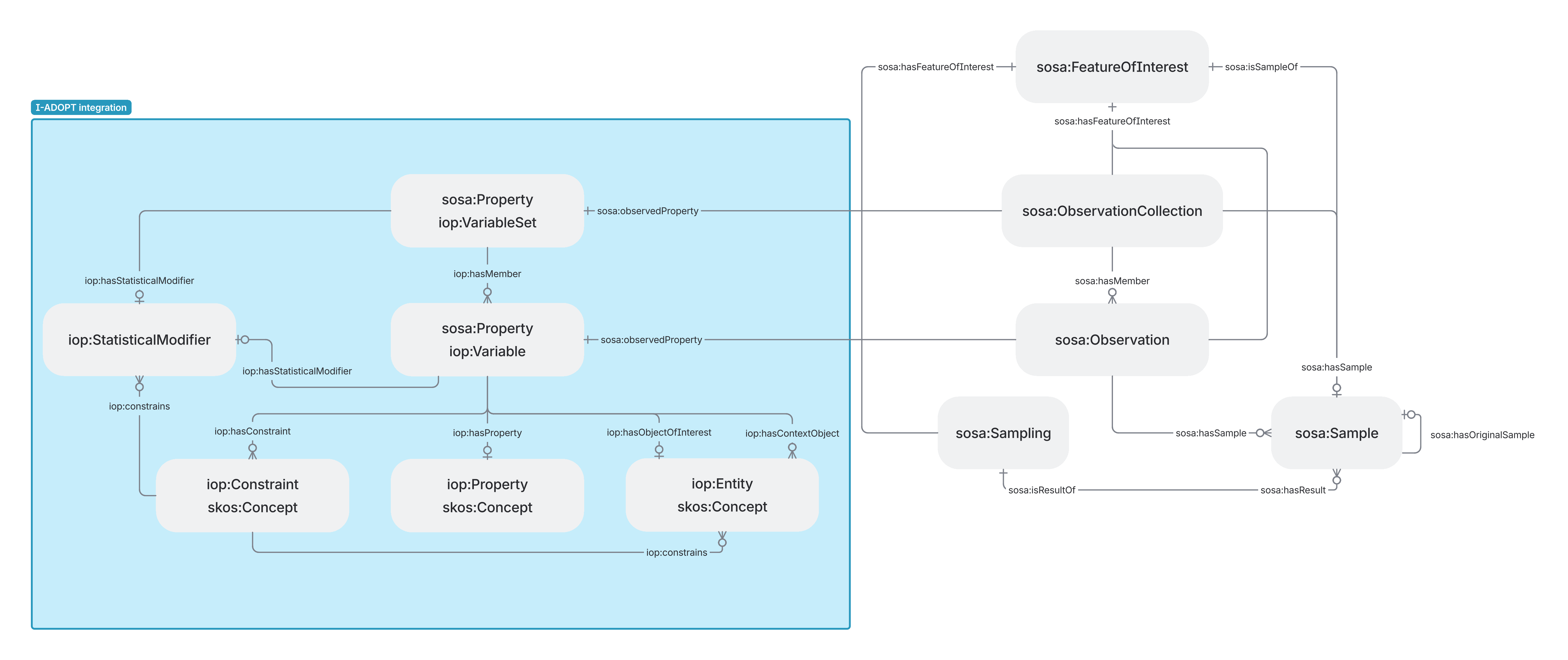
We use the I-ADOPT framework ontology to provide more structured observation data. By grouping observations with sosa:ObservationCollections and iop:VariableSets, we describe the possible set of variables measured by a given observation. We relax the predicates for describing iop:Variables, making them optional, allowing datasets to be provided without each variable of each observation being exhaustively described with the I-ADOPT framework.
sosa:FeatureOfInterest
the entity whose property is being estimated by an Observation, or whose property is being manipulated by an Actuation, or which is being sampled or transformed by an act of Sampling
– SOSA/SSN 2023 spec
sosa:FeatureOfInterests that have a geographical location should also be a geo:Feature. Generally they should have a Point or MultiPolygon geometry. For example, a sampling point in the water quality explorer is a single location where samples are consistently taken from. This geo:Feature should be described by a Point.
Predicate |
Range |
Requirement |
Cardinality |
Notes |
|---|---|---|---|---|
sosa:hasProperty |
a sosa:Property |
Should |
0..* |
If the feature itself has properties which are observed |
defra-core:hasClassification |
a skos:Concept |
May |
0..1 |
If one has been provided by the relevant body |
sosa:Procedure
workflow, protocol, plan, algorithm, or computational method specifying how to make an Execution
– SOSA/SSN 2023 spec
We use sosa:Procedure to provide additional information about the sosa:Sampling method. The sosa:Procedure should either be a blank node or an anchor e.g. http://environment.data.gov.uk/ecology-and-fish/benthic/sampling-point/135967-v1/sample/514432-v1-rA-a527041#procedure. Where it makes sense to create a vocabulary of sosa:Procedures then each sosa:Procedure will be defined as a skos:Concept within a skos:ConceptScheme.
Predicate |
Range |
Requirement |
Cardinality |
Notes |
|---|---|---|---|---|
skos:prefLabel |
Literal xsd:string |
Must |
1..* |
|
skos:notation |
Literal xsd:string |
Must |
1..* |
|
skos:inScheme |
a skos:ConceptScheme |
Must only if the sosa:Procedure is also a skos:Concept otherwise not needed. |
1..* (if also a skos:Concept) |
|
skos:definition |
Literal xsd:string |
Should |
0..* |
sosa:Property
identifiable quality of features of interest that can be observed or acted upon
– SOSA/SSN 2023 spec
A sosa:Property must also be a skos:Concept, to provide additional contextual information about the property, as well as its relationships to other properties. skos:notation should be used to indicate the code of the property, if one exists.
A sosa:Property must also be a iop:Variable.
Predicate |
Range |
Requirement |
Cardinality |
Notes |
|---|---|---|---|---|
skos:prefLabel |
Literal xsd:string |
Must |
1..* |
|
skos:altLabel |
Literal xsd:string |
May |
0..* |
|
skos:definition |
Literal xsd:string |
May |
0..* |
A property should be described with the predicates supported by iop:Variable, or a definition provided with skos:definition. |
sosa:Sampling
act of carrying out a SamplingProcedure using a Sampler to create one or more Samples of a FeatureOfInterest
– SOSA/SSN 2023 spec
A sosa:Sampling represents a snapshot from which sosa:Samples can be taken, and those in turn are observed to produce sosa:Observations.
Predicate |
Range |
Requirement |
Cardinality |
Notes |
|---|---|---|---|---|
sosa:hasFeatureOfInterest |
a sosa:FeatureOfInterest |
Must |
1 |
|
sosa:resultTime |
Literal xsd:dateTime, xsd:date, xsd:gYearMonth, and/or xsd:gYear. |
Must |
1 |
Time at which the result became available. Typically the same as sosa:endTime. |
sosa:hasResult |
a sosa:Sample |
Should |
0..* |
If a sosa:Sampling has one or more sosa:Samples then we use sosa:hasResult to provide the sosa:Samples |
sosa:usedProcedure |
a sosa:Procedure |
May |
0..* |
|
geo:hasGeometry |
a geo:Geometry |
May |
0..1 |
geo:hasGeometry is used on the sosa:Sampling to describe the location at which the sosa:Sampling took place or it can be used to describe the sosa:Sample location. |
sosa:startTime |
Literal, includes xsd:dateTime |
May |
0..1 |
Time at which the sampling began |
sosa:endTime |
Literal, includes xsd:dateTime |
May |
0..1 |
Time at which sampling completed |
sosa:phenomenonTime |
Literal, includes xsd:dateTime |
May |
0..1 |
Time of the phenomenon being measured |
sosa:Sample
Samples are typically subsets or extracts from an entity or feature. Every sample is expected to (eventually) be the feature of interest of an Observation
– SOSA/SSN 2023 spec
A sample is a result of a sampling of a feature of interest, from which observations can be made.
Each sample must have a related sosa:Sampling to provide additional contextual information about the sample.
Predicate |
Range |
Requirement |
Cardinality |
Notes |
|---|---|---|---|---|
sosa:isSampleOf |
a sosa:FeatureOfInterest or a sosa:Sample |
Must |
1 |
|
sosa:isResultOf |
a sosa:Sampling |
Must |
1 |
|
sosa:hasOriginalSample |
a sosa:Sample |
May |
0..1 |
If this sample was created from, or is a subset of, an original sample, this points to the original sosa:Sample. |
defra-core:hasClassification |
a skos:Concept |
May |
0..1 |
A classification of the sample e.g. survey based sample, run based sample, individual animal sample. |
sosa:ObservationCollection
An instance of ObservationCollection represents a container for a set of data derived from observations. This broadly corresponds with the class dcat:Dataset from the Data Catalog Vocabulary
– SOSA/SSN 2023 spec
A sosa:ObservationCollection must group all sosa:Observations made on a single sosa:Sample, if there is more than one observation for the given sample.
Predicate |
Range |
Requirement |
Cardinality |
Notes |
|---|---|---|---|---|
sosa:hasFeatureOfInterest |
a sosa:FeatureOfInterest |
Must |
1 |
|
sosa:observedProperty |
a iop:VariableSet |
Must |
1 |
|
sosa:hasSample |
a sosa:Sample |
Should |
0..1 |
sosa:Observation
act of carrying out an ObservingProcedure using a Sensor to estimate or calculate a value of an observable Property of a FeatureOfInterest
– SOSA/SSN 2023 spec
An observation has a result from a sample for a property of a given feature of interest.
Predicate |
Range |
Requirement |
Cardinality |
Notes |
|---|---|---|---|---|
sosa:hasFeatureOfInterest |
a sosa:FeatureOfInterest |
Must |
1 |
|
sosa:observedProperty |
a sosa:Property |
Must |
1 |
|
sosa:phenomenonTime |
Literal xsd:dateTime |
Must |
1 |
Time at which the property was measured |
sosa:hasResult |
a rdfs:Resource |
Must |
1 |
Should use an existing ontology for this when applicable, e.g. http://qudt.org/schema/qudt and http://qudt.org/schema/qudt/unit, as shown in the SOSA/SSN spec: If the result is a mean value, qudt:standardUncertainty should provide the standard deviation if it is specified. If the result is a range, qudt:minExclusive and qudt:maxExclusive should be used for exclusive values in the range, and qudt:minInclusive and qudt:maxInclusive should be used for inclusive values in the range. |
sosa:hasSample |
a sosa:Sample |
Should |
0..1 |
Sample from which this observation was made, if a sample was used |
sosa:isMemberOf |
a sosa:ObservationCollection |
May |
0..1 |
If several observations were made on a single Sample, they should be grouped into a sosa:ObservationCollection with this predicate. |
iop:VariableSet
An aggregation class to group a set of variable for a specific purpose.
– I-ADOPT Framework ontology
Together with sosa:ObservationCollections, we use iop:VariableSets to describe all possible variables that may be observed from a single sample.
Predicate |
Range |
Requirement |
Cardinality |
Notes |
|---|---|---|---|---|
rdfs:label |
Literal xsd:string |
Must |
1..* |
|
iop:hasMember |
a iop:Variable |
Must |
1..* |
|
iop:hasApplicableObjectOfInterest |
a iop:Entity |
Should |
0..* |
|
rdfs:comment |
Literal xsd:string |
May |
0..* |
|
iop:hasApplicableStatisticalModifier |
a iop:StatisticalModifier |
May |
0..* |
If a modifier applies to the entire iop:VariableSet |
iop:hasApplicableProperty |
a iop:Property |
May |
0..* |
iop:Variable
A description of something observed or derived, minimally consisting of an ObjectOfInterest and its Property.
– I-ADOPT Framework ontology
A variable is directly associated with a sosa:Observation to describe the meaning of its sosa:hasResult.
Describes an iop:Property of an iop:Entity, potentially involving an iop:Constraint, a contextually related iop:Entity, and iop:StatisticalModifier.
Predicate |
Range |
Requirement |
Cardinality |
Notes |
|---|---|---|---|---|
skos:prefLabel |
Literal xsd:string |
Must |
1..* |
|
iop:hasProperty |
a iop:Property |
Should |
0..1 |
|
skos:altLabel |
Literal xsd:string |
May |
0..* |
|
skos:definition |
Literal xsd:string |
May |
0..* |
A property should be described with the predicates supported by iop:Variable, or a definition provided with skos:definition. |
iop:hasConstraint |
a iop:Constraint |
May |
0..* |
|
iop:hasObjectOfInterest |
a iop:Entity |
May |
0..* |
|
iop:hasContextObject |
a iop:Entity |
May |
0..* |
|
iop:hasStatisticalModifier |
a iop:StatisticalModifier and a skos:Concept |
May |
0..1 |
iop:Property
A type of a characteristic of the ObjectOfInterest.
– I-ADOPT Framework ontology
For example: depth, temperature, sex, width.
A iop:Property must also be a skos:Concept. This allows us to describe them in a consistent manner to other concepts.
A iop:Property should be a qudt:QuantityKind. We should extensive vocabulary it provides when possible, and define our own qudt:QuantityKinds when necessary.
Predicate |
Range |
Requirement |
Cardinality |
Notes |
|---|---|---|---|---|
skos:prefLabel |
Literal xsd:string |
Must |
1..* |
|
skos:definition |
Literal xsd:string |
Should |
0..* |
|
skos:altLabel |
Literal xsd:string |
May |
0..* |
iop:Entity
An object or process that has a role in an observation.
– I-ADOPT Framework ontology
For example: a river, or a fish.
A iop:Entity must also be a skos:Concept. This allows us to describe them in a consistent manner to other concepts.
Predicate |
Range |
Requirement |
Cardinality |
Notes |
|---|---|---|---|---|
skos:prefLabel |
Literal xsd:string |
Must |
1..* |
|
skos:definition |
Literal xsd:string |
Should |
0..* |
|
skos:altLabel |
Literal xsd:string |
May |
0..* |
iop:Constraint
A Constraint limits the scope of the observation and confines the context to a particular state. It describes properties of the involved entities that are relevant to the particular observation.
– I-ADOPT Framework ontology
A iop:Constraint must also be a skos:Concept. This allows us to describe them in a consistent manner to other concepts.
Predicate |
Range |
Requirement |
Cardinality |
Notes |
|---|---|---|---|---|
skos:prefLabel |
Literal xsd:string |
Must |
1..* |
|
skos:definition |
Literal xsd:string |
Should |
0..* |
|
iop:constrains |
a iop:Entity |
Should |
0..* |
|
skos:altLabel |
Literal xsd:string |
May |
0..* |
iop:StatisticalModifier
The statistical modifier describes which statistical measure has been applied.
– I-ADOPT Framework ontology
For example: mean, average, minimum, maximum, count.
We prioritise the use of SDMX CL_STATISTICAL_OPERATION definitions for statistical operations. When referring to statistical modifiers or aggregation methods, these always point to our own Concept Scheme for statistical methods or operations. Each concept within this scheme implicitly aligns with SDMX notations. If SDMX is not applicable and a precise URI definition exists, such as those provided by DDI, we use skos:exactMatch to link our concept to the corresponding DDI URI.
If no suitable term exists within SDMX, we fall back to the DDI Controlled Vocabulary for Aggregation Methods. Where no appropriate definition is available there either, we create a new concept. Such concepts are defined as both a skos:Concept and an iop:StatisticalModifier.
Observation JSON-LD mapping
RDF Attribute |
JSON-LD key |
JSON-LD value |
Notes |
|---|---|---|---|
sosa:hasFeatureOfInterest |
hasFeatureOfInterest |
JSON-LD |
|
sosa:hasResult |
hasResult |
JSON-LD |
|
qudt:hasUnit |
hasUnit |
URI of qudt:Unit or JSON-LD containing the qudt:Unit definition |
|
sosa:observedProperty |
observedProperty |
JSON-LD |
|
sosa:phenomenonTime |
phenomenonTime |
Literal value as string |
|
sosa:resultTime |
resultTime |
Literal value as string |
|
sosa:startTime |
startTime |
Literal value as string |
|
sosa:isSampleOf |
isSampleOf |
JSON-LD |
|
sosa:isResultOf |
isResultOf |
JSON-LD |
|
sosa:hasSample |
hasSample |
JSON-LD |
Applicable to sosa:Observation |
hasObservations |
URI to endpoint which provides related sosa:Observations |
Applicable to sosa:FeatureOfInterests and sosa:Samples |
|
hasSamplings |
URI to endpoint which provides related sosa:Samplings |
Applicable to sosa:FeatureOfInterests |
Observation worked example
The Ecology and Fish API currently in development describes observational data using the SOSA/SSN, QUDT and I-ADOPT vocabularies. The cut down example below describes an observation describing the count of a particular taxon of fish in a given sample. The sosa:hasResult block breaks down the raw result into its value, units and other additional information. The sosa:observedProperty block breaks down the observation property into individual components using I-ADOPT.
 {
 "id": "http://environment.data.gov.uk/ecology-and-fish/benthic/sampling-point/135966-v1/sample/514427-v1-rA-a527036/observation/taxon=NBNSYS0100049570@abundance,statistical-modifier=count",
 "@type": "sosa:Observation",
 "hasResult": {
   "id": "http://environment.data.gov.uk/ecology-and-fish/benthic/sampling-point/135966-v1/sample/514427-v1-rA-a527036/observation/taxon=NBNSYS0100049570@abundance,statistical-modifier=count#result",
   "@type": "qudt:QuantityValue",
   "hasUnit": "unit:INDIV",
   "numericValue": 2,
   "standardUncertainty": null
 },
 "observedProperty": {
   "id": "http://environment.data.gov.uk/ecology-and-fish/benthic/sampling-point/135966-v1/sample/514427-v1-rA-a527036/observation/taxon=NBNSYS0100049570@abundance,statistical-modifier=count#observedProperty",
   "@type": [
     "sosa:Property",
     "iop:Variable"
   ],
   "hasProperty": "quantitykind:Count",
   "hasConstraint": [],
   "hasObjectOfInterest": "http://environment.data.gov.uk/ecology-and-fish/benthic/taxa/Concept/NBNSYS0100049570",
   "hasStatisticalModifier": "https://environment.data.gov.uk/ecology-and-fish/statistical-modifiers/Concept/count"
 }
}
Cubes
CSV-W
CSV-W (CSV on the Web) is a standard for describing and clarifying the content of CSV tables. While CSV is one of the most common formats for sharing tabular data, it contains very little information about the meaning or structure of the data it holds. CSV-W addresses this by allowing datasets to be accompanied by structured metadata (a .json metadata file). This metadata file can describe column data types, identifiers, relationships between tables, and links to external vocabularies. As a result the data becomes more interpretable and reusable across systems. CSV-W enables tabular data to be transformed into RDF by defining how rows and columns map to RDF triples.
Our datasets will be accessible through a CSV endpoint e.g. https://environment.data.gov.uk/water-quality/sampling-point/TH-PBRR0047.csv, and if users require the JSON metadata file then the JSON file will be accessible via a HTTP GET request with an Accept header of application/csvm+json.
Cubes worked example
Consider the following CSV table containing water quality observations:
id |
samplingPoint.notation |
Area |
Phenomenon Time |
determinand.prefLabel |
result |
unit |
|---|---|---|---|---|---|---|
https://environment.data.gov.uk/water-quality/sampling-point/TH-PBRR0047/sample/1436878/observation/0061 |
TH-PBRR0047 |
THAMES - HERTS AND NORTH LONDON |
2025-04-25T13:13:00 |
pH |
7.83 |
PH UNITS |
Using the table above we would define a JSON metadata file to describe this CSV as follows:
{
  "@context": "http://www.w3.org/ns/csvw.jsonld",
  "url": "https://environment.data.gov.uk/water-quality/sampling-point/TH-PBRR0047.csv",
  "dcterms:title": "Sample Dataset",
  "dcterms:description": "A dataset containing observations at the TH-PBRR0047 Sampling Point.",
  "dcterms:publisher": "https://environment.data.gov.uk",
  "dcterms:license": "https://www.nationalarchives.gov.uk/doc/open-government-licence/version/3/",
  "dcterms:created": "2026-03-17T14:32:05Z",
  "tableDirection": "ltr",
  "tableSchema": {
    "columns": [
      {
        "name": "id",
        "titles": "id",
        "datatype": "string",
        "aboutUrl": "{id}"
      },
      {
        "name": "samplingPoint.notation",
        "titles": "samplingPoint.notation",
        "datatype": "string"
      },
      {
        "name": "Area",
        "titles": "Area",
        "datatype": "string",
        "propertyUrl": "http://purl.org/linked-data/sdmx/2009/dimension#refArea"
      },
      {
        "name": "Phenomenon Time",
        "titles": "Phenomenon Time",
        "datatype": "dateTime",
        "propertyUrl": ["http://purl.org/linked-data/sdmx/2009/dimension#refPeriod", "http://www.w3.org/ns/sosa/phenomenonTime"]
      },
      {
        "name": "determinand.prefLabel",
        "titles": "determinand.prefLabel",
        "datatype": "string"
      },
      {
        "name": "result",
        "titles": "result",
        "datatype": "decimal",
        "propertyUrl": ["http://purl.org/linked-data/sdmx/2009/measure#obsValue"]
      },
      {
        "name": "unit",
        "titles": "unit",
        "datatype": "string",
        "propertyUrl": ["http://purl.org/linked-data/sdmx/2009/attribute#unitMeasure", "http://qudt.org/schema/qudt#hasUnit"]
      }
    ]
  }
}
API behaviour
Generally, we endeavour to bring Linked Data to JSON users, not force Linked Data conventions upon them. URIs follow REST patterns (/{dataset}/{class}/{instance}), not traditional semantic web patterns (/id/, /def/).
Each service, hosted at a stable base URL, and is composed of one, top-level, dcat:Catalog. This catalog contains skos:ConceptSchemes, dcat:Datasets, dcat:DataServices, etc, which in turn contain various other classes of the above Data Types.
URL structure
{base URL}/{catalog}/{dataset}/{RDF class}/{instance identifier}
Text-based instance identifiers must always use kebab-case and be URI-safe (as per RFC 3896), regardless of whether they are created internally or derived from source data. Source-provided identifiers or notations that are not text-based should retain their original format so long as the URI is valid.
RDF class names must be in PascalCase, URI-safe, and unique within a dataset
Datasets can contain multiple classes (e.g., /wetlands/WetlandSite/{id} and /wetlands/WetlandBoundary/{id})
Datasets with simple skos:ConceptScheme structures use Concept as the class (e.g. /determinands/Concept/DO)
Datasets with a skos:ConceptScheme of geographies use Geography as the class (e.g. /local-authorities/Geography/E06000001)
For example:
http://example.org/example-catalog/example-dataset/Concept/some-concept
The above can be broken down into the following:
Base URL |
Catalogue |
Dataset |
Class |
Instance |
|---|---|---|---|---|
http://example.org/ |
example-catalog/ |
example-dataset/ |
Concept |
some-concept` |
The source of the unique identifier of a instance varies with its class. We should use the following predicate for each class, and ensure that they are consistent when an instance has multiple classes:
Class |
Unique identifier predicate |
|---|---|
dcat:Catalog
dcat:Dataset
dcat:DataService
dcat:Distribution
|
dcterms:title |
skos:ConceptScheme
skos:Concept
|
skos:notation |
Where there are multiple instances of the same candidate predicate, the one using the primary language of the service should be chosen. In the case of DSP, that would be English.
Catalogue data endpoints
Endpoint |
Purpose |
Formats |
|---|---|---|
/ |
Root catalogue (list of datasets) |
application/ld+json |
/catalog or /catalogue |
Explicit catalogue metadata (DCAT) |
application/ld+json |
Concept data endpoints
Endpoint |
Purpose |
Formats |
|---|---|---|
/{dataset} |
Information about the Concept Scheme |
application/ld+json
application/x-jsonlines
text/csv
|
/{dataset}/Concept |
List member concepts |
application/ld+json
application/x-jsonlines
text/csv
|
/{dataset}/Concept/{instance} e.g.
|
Individual concept |
application/ld+json
application/x-jsonlines
text/csv
|
Geography data endpoints
Endpoint |
Purpose |
Formats |
|---|---|---|
/{dataset}/Geography e.g.
|
Collection of geographies |
application/ld+json
application/x-jsonlines
application/geo+json
text/csv
|
/{dataset}/Geography/{instance} e.g.
|
Individual geography |
application/ld+json
application/x-jsonlines
application/geo+json
text/csv
|
Custom data endpoints
Endpoint |
Purpose |
Formats |
|---|---|---|
/{dataset}/{ClassName} e.g.
|
Collection of instances for that class, and class definition |
application/ld+json
application/x-jsonlines
text/csv
|
/{dataset}/{ClassName}/{instance} e.g.
|
Individual class instance |
application/ld+json
application/x-jsonlines
text/csv
|
Observation data endpoints
Endpoint |
Purpose |
Formats |
|---|---|---|
/sampling-point/{id} e.g.
|
Sampling point metadata. Points to the endpoint for observations with hasObservations, defined to be an inverse of sosa:hasUltimateFeatureOfInterest. |
application/ld+json
application/geo+json
|
/sampling-point/{id}/observation e.g.
|
Observations at specific point |
application/ld+json
application/x-jsonlines
text/csv
|
/sampling-point/{id}/sample/{sample-id}
e.g.
|
Individual sample and sampling metadata. In the interest of usability, we don’t segregate the information of a sample and sampling. When a sample is requested its corresponding sampling is returned as an embedded subject with an ID suffix of #sampling. |
application/ld+json |
/sampling-point/{id}/observation-collection/{obs-collection-id} |
A group of observations |
application/ld+json
application/x-jsonlines
|
/sampling-point/{id}/sample/{sample-id}/observation/{obs-id} e.g.
|
Individual observation |
application/ld+json |
/variable-set |
A variable set definition. Each predicate points to a concept scheme endpoint, using Hydra’s memberAssertion to indicate that all concepts in that scheme are in the range of the variable set. |
application/ld+json |
/data/sampling-point |
Bulk sampling point download |
application/ld+json
application/geo+json
|
/data/observation |
Bulk observation download |
application/ld+json
application/x-jsonlines
text/csv
|
Key patterns:
Nested access: Drill down from sampling point → sample → observation
Bulk access: Query parameters for filtering (e.g. /data/observation?pointNotation={id})
Pagination: All endpoints paginated using Hydra; in-memory formats (JSON-LD, GeoJSON) have lower max limits than streaming formats (CSV, JSON-Lines)
Uniquely identifying sites, sample/samplings, and observations
Typically, a dataset will provide a way to uniquely address a sampling point and sample/sampling, in which case we should reuse those. For the sampling point, those identifiers will be the skos:notation of the geo:Feature + skos:Concept + sosa:FeatureOfInterest instance. For the sample/sampling, this may require concatenation to form a unique ID.
Datasets typically provide many observed results for a given sample, and each of these must be uniquely addressable by a obs-id. These IDs must be programatically generated from the dimensions of the observations, which are unique to each dataset. These IDs should generally be human-readable, but they need not be human-writable; users are expected to use API endpoints to discover unique observations, not manually generate them.
The general pattern of observation IDs should follow: dimension 1[,dimension 2,…]@[,statistical modifier].
The order of dimensions must be consistent for the given dataset. Dimensions should generally be ordered, as applicable, first by time, then geography. Subsequent dimensions should be ordered by which eliminates the most data.
When a dimension is a range, the SDMX framework's encoding pattern should be used.
Each dimension, measures, and statistical modifier may be defined as a skos:Concept grouped into appropriate skos:ConceptSchemes. All measures should be part of the same skos:ConceptScheme, all statistical modifiers part of the same skos:ConceptScheme, and each dimension may form their own skos:ConceptScheme.
For example, the Ecology & Fish Data Explorer (EFDE) dataset provides multiple “runs" for each sample/sampling, each providing several observations including length & weight, broken down by species. Each species has a unique numeric ID (skos:notation) maintained by the department responsible for the dataset, so we reuse this in the observation IDs.
Possible observation URIs include:
/sampling-point/4787/sample/29317-run1/observation/fish-species=chub@property=abundance,aggregation=count: Total number of Chub individuals measured in run 1 of sample 29317 at sampling point 4787.
/sampling-point/4787/sample/29317-run1/observation/fish-species=herring,fish-part=leftFin,age-range=0-3@property=length,aggregation=mean: Mean length of left fin of Herrings who are 0-3 years old.
Cube data
Protected endpoints
The following paths are reserved and cannot be used as dataset names, class names, or instance names.
Category |
Endpoint |
Purpose |
|---|---|---|
Infrastructure |
/admin |
Dataset & user management |
Infrastructure |
/health, /status, /metrics |
Monitoring |
Infrastructure |
/docs, /api-docs, /swagger, /openapi.json |
Documentation |
Data Operations |
/data |
Bulk download namespace |
Data Operations |
/catalog, /catalogue |
Catalogue metadata |
Data Operations |
/bulk |
Reserved for future bulk operations |
Linked Data Federation |
/id, /def, /doc |
Reserved (not used in FAIRground, but protected for compatibility) |
Linked Data Federation |
/sparql |
Reserved for GraphDB federation |
Linked Data Federation |
/query |
Reserved for custom query interfaces |
Authentication |
/auth, /login, /logout, /token |
|
Discovery |
/.well-known |
RFC 8615 discovery mechanisms |
Technical |
/api |
Reserved for HTML & Node.js API roots use, not for API versioning |
JSON-LD representations
When transferring RDF data to and from our APIs, the primary format we should use is JSON-LD. Other formats may be supported when requested via the Accept header.
JSON-LD context files are used to provide mappings JSON-LD properties to RDF vocabularies.
Our JSON-LD representations should be as useful as possible to both users who are interested in our linked data, and also those looking to consume our data in the traditional manner of RESTful APIs returning JSON. The latter category of users should be able to ignore all properties with the @ prefix, and still be able to access the data they are interested in, including via URIs which direct them to other endpoints.
Subjects provided in JSON-LD format should have their types specified with type, contexts should provide the mapping type → @type.
URIs that are addressable via a RESTful API should be specified with the key id, and the context should provide the mapping id → @id. We still use @id as a key where the particular identifier is not directly available as RESTful endpoint; typically used to designate blank nodes or subjects which are dependent on its containing subject (i.e. the geo:Geometry embedded in a sosa:FeatureOfInterest).
The context must set @base to the appropriate URI so that all relative id values expand correctly within the intended vocabulary.
Generally, the JSON-LD property should be the name of the predicate without any leading namespace or absolute URI. E.g. skos:prefLabel → "prefLabel". In the case that there is a name conflict, the conflict should be resolved in a manner that leaves it unambiguous which ontology each property belongs to.
When a resource may have related child resources, the API should generally return the URI of an endpoint which provides those resources. When related resources are instead provided as nested objects, their contents may be truncated to provide only the relevant properties. id should provide the URI of each related resource.
When a resource has multiple values for a given predicate, these values should be grouped into an array.
Predicates with literal values in a particular language should be appropriately labelled with the @language and @direction fields. @language and @direction should not be set in the context, to avoid mislabelling all string values as using a specific language or direction. Contexts which provide values with languages should have the mapping value → @value, language → @language and direction → @direction.
Fields that should set @language includes skos:prefLabel, skos:altLabel, skos:note, skos:definition.
Fields that should not set @language includes skos:notation.
Hydra
We use Hydra to support pagination in our RESTful API endpoints, to assert that the pagination objects are all of a set type.
Hydra's memberAssertion functionality is used to conveniently inject additional predicates into members of collections, when it would be tedious or error-prone to add the triple explicitly for each member.
Hydra must not be used for pagination for GeoSPARQL data, instead we must use the query parameter system as defined in the GeoSPARQL specification, section F.2.
JSON-LD contexts
JSON-LD context worked example
In Turtle syntax:
@base <http://example.org/> .
@prefix skos: <http://www.w3.org/2004/02/skos/core#> .

<Some-Concept> a skos:Concept ;
  skos:notation "some-concept" ;
  skos:prefLabel "An English name"@en, "Enw Cymreig"@cy ;
  skos:altLabel "Alternative name"@en ;
  skos:broader <Parent-Concept> .

<Parent-Concept> a skos:Concept ;
  skos:notation "parent-concept" ;
  skos:prefLabel "Parent concept name"@en ;
JSON-LD representation:
{
  "@context": "http://example.org/context.json-ld",
  "id": "http://example.org/Some-Concept",
  "type": "skos:Concept",
  "notation": "some-concept",
  "prefLabel": [
    { "value": "An English name", "language": "en" },
    { "value": "Enw Cymreig", "language": "cy" }
  ],
  "altLabel": { "value": "Alternative name", "language": "en", "direction": "ltr" },
  "broader": {
    "id": "http://example.org/Parent-Concept",
    "type": "skos:Concept",
    "notation": "parent-concept",
    "prefLabel": { "value": "Parent concept name", "language": "en", "direction": "ltr" }
  }
}